Wednesday, April 10th:
We got up early, had breakfast, packed an overnight bag, and headed to the South Coast. Joyce was watching the weather closely and made sure she double checked the Icelandic Roads website. The South Coast is the windiest part of the country and if the winds get really bad they will close the roads.
We passed by some spectacular sites as we drove southeast past Selfoss and along Route 1.
During the drive Joyce told us more about the geology of Iceland, where we were going, and some of the cool things we are going to see over the next two days.
We also went over some common Icelandic terms. Icelandic is very close to Old Norse and even though the words are long they make sense once you break them down. For example: Reykjavík. Reykja means "smoke" and vík means "bay." There are common words that we were seeing a lot:
kirkja = church
jökull = glacier
foss = waterfall
fjara = beach
fjall = mountain
vík = bay
Eyjafjallajökull is the name of the glacier that sits on top of Eyjaföll, which is the name of the volcano. Makes sense 🙂 The Icelandic people are very literal.
[Ölfusá river by Selfoss]


[Hraungerðiskirkja - It's a church, right? Because kirkja means church in Old Norse!]

We drove through the tiny town on Hella where we could get a great view of the infamous Hekla volcano ("Gateway to Hell" in Old Norse). This is one of the most active volcanos in Iceland and has erupted 20 times in the last 800 years. Hekla is part of a very busy volcanic ridge which is responsible producing large amounts of lava which currently covers 10% of the island.
[Hekla]

We had a spectacular view of the Eyjafjallajökull and Mýrdalsjökull glaciers from Route 1. These glaciers are massive!


[Cone]


We then crossed a large sandur, which is an outwash plain from the Eyjafjallajökull and Mýrdalsjökull glaciers. As the glacier melts the water and sediment flow out towards the ocean. The glacier grinds down the sediment and makes it very fine. The outwash plains look like giant, black sand deltas.
Iceland is famous for these types of glacial features. If you see one you know there is a glacier close by.
[Sandur flowing out to the sea]


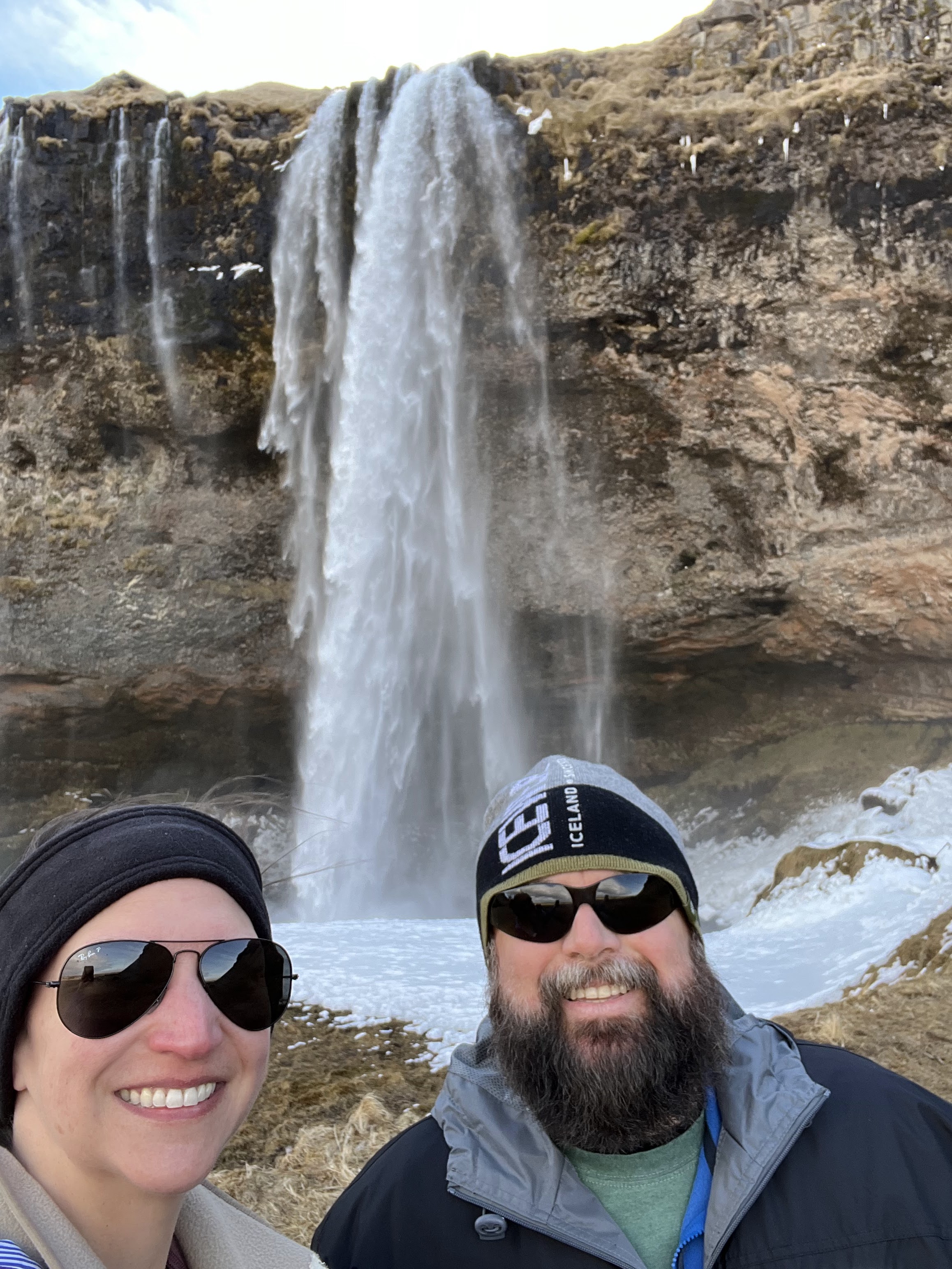
After driving for an hour we arrived at our first stop: Seljalandsfoss.
This 60 meter high waterfall originates at the Eyjafjallajökull, which is the volcano that erupted in 2010 and caused a lot of flight delays. During the summer you can walk behind the waterfall and enter a cave. The pathway was closed due to too much ice, so we didn't get to see the backside of water. Bummer!


After getting our pictures we walked along a path until we came to a...


...slot canyon?!

We entered the canyon and quickly realized why Joyce told us to wear water proof boots and rain gear today!

We found the secret waterfall, Gljufrabui!


We got pretty wet while trying to get pictures, but that's okay! We then walked back to Seljalandsfoss where Josh was able to get a few cool pictures of the waterfall and a sun halo.


We left Seljalandsfoss and continued southeast along Route 1.


[Around every corner is something new!]


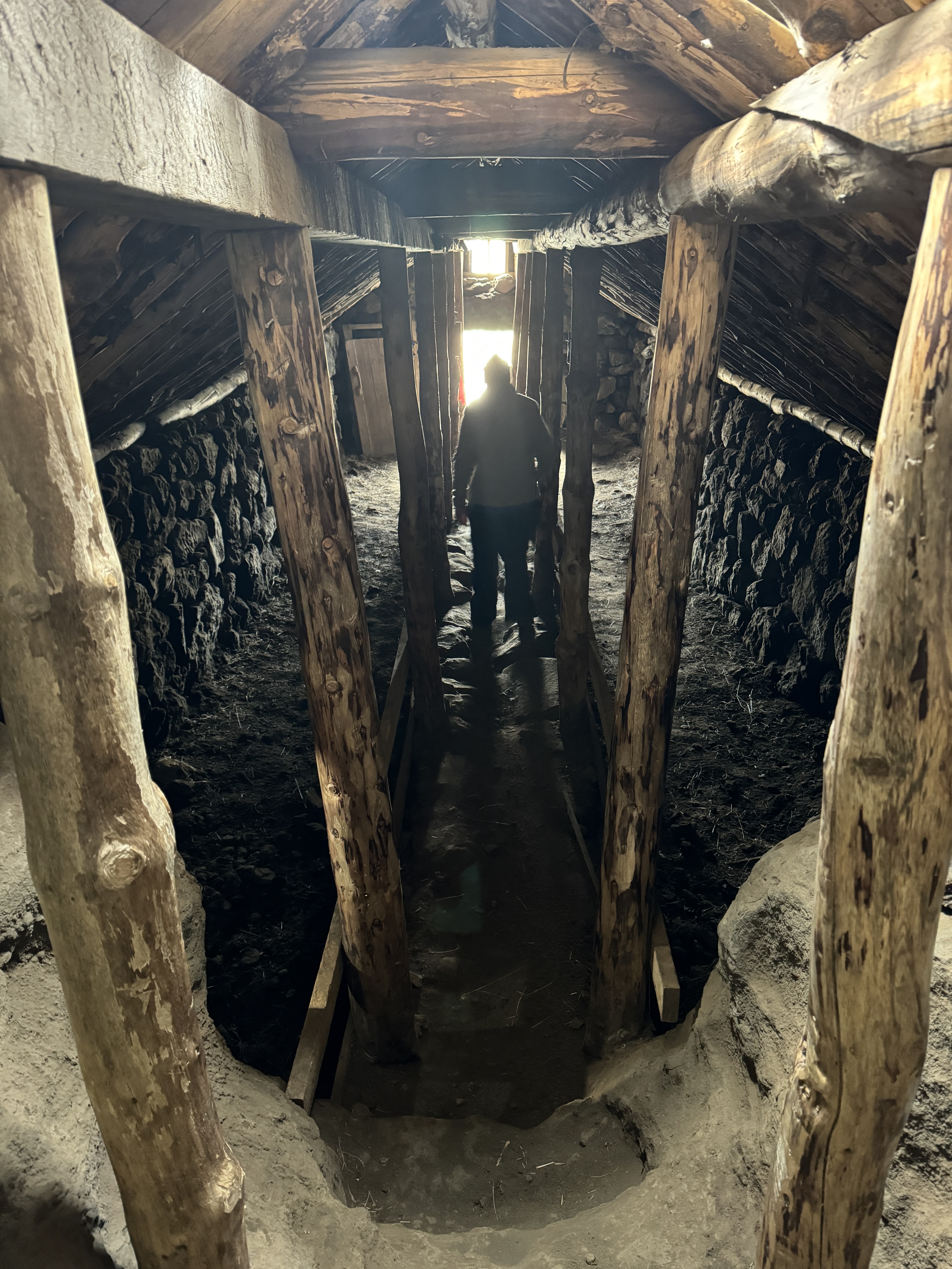
We then stopped at the Rútshellir, which is the largest man made cave in Iceland. It was likely constructed in the 1700s and had a variety of uses.

You enter through the tiny turf house opening, make your way through the interior on wooden planks, and then enter the cave section at the back.


[Cave]

[Heading back out]
I love these ladders! It makes it so much easier to climb over fences.

We continued along Route 1 and came to Skógafoss just a few minutes later.
This waterfall is huge and powerful!


[I love black sand]

After seeing the waterfall from the bottom we hiked up 527 steps to see it from the top.


[Made it!]


We hit the road again just as the weather started to turn. Joyce told us that the next section of road is the most dangerous because it is so windy and the weather can change very quickly.
[More sandur's]


We made our way to the southern most point on the island: Dyrhólaey Lighthouse. As we approached the large rock we started putting back on all of our layers. It was going to be windy up on top of that rock!

[Can you see the lighthouse on top of the large rock on the far left side? It's pretty tiny.]

Joyce said that if we were going see puffins it would be here along the sea cliffs. I wanted to look for them, but it was too windy!
[Me looking for puffins and overlooking the Dyrhólaey black sand beach]

[Dyrhólaey black sand beach]

We made our way to the end of the rock and found these beautiful sea arches!

[So awesome!]

[Dyrhólaey Lighthouse]

[View of the Reynisfjara Black Sand Beach and the Reynisdrangar (basalt sea stacks) from the Dyrhólaey Lighthouse]


We left the lighthouse and made our way to the Reynisfjara Black Sand Beach.


[Reyniskirkja]


We made it to the beach, but of course, the weather decided to get super nasty! The wind and rain were pretty intense, but that didn't stop us!
[Beware of sneaker waves and stay away from the water]

[Reynisfjara Black Sand Beach with one of the Reynisdrangar]


[Organ pipe basalt columns with the Reynisdrangar]


[It was very chilly!]


[The geology here is incredible!]


After exploring the beach a bit we jumped back in the warm car and headed to Vík, which was on the other side of the mountain.
[Vík i Myrdal Church]

We drove through Vík and out onto the Mýrdalssandur, which is a large outwash plain (sandur) from the Mýrdalsjökull glacier. This is where the opening shots from Rogue One were filmed!
[*Not my picture*]

[Picture from Rogue One]

From there we went to the Viking Park where we found the Yoda Cave!


The cave doesn't have any significance to Star Wars other than the fact that the opening looks like Yoda. Isn't it so cool?!

[Oystercatcher]

We grabbed dinner at a nice restaurant in Vík, Suður-Vík. Josh got a reindeer burger and I got a seafood soup. Everything was delicious and fresh!


That night we stayed at the Black Beach Suites. On a clear day you would have a view of the black sand beach, but it was a little cloudy.
[Our suite]

[Bathroom]

Our travels today:

Tomorrow we are going to head east along the coast until we reach the Diamond Beach. It's going to be a great day!
No comments:
Post a Comment