Thursday, April 11th:
We woke up to clouds, rain, and wind, which is very common down on the South Coast. We ate some breakfast (skyr!), packed our bags, and then got picked up by Joyce.
[Breakfast of champions!]
Joyce said she's been watching the weather closely and she's going to adjust our itinerary a bit. One of the many perks of having a private guide!
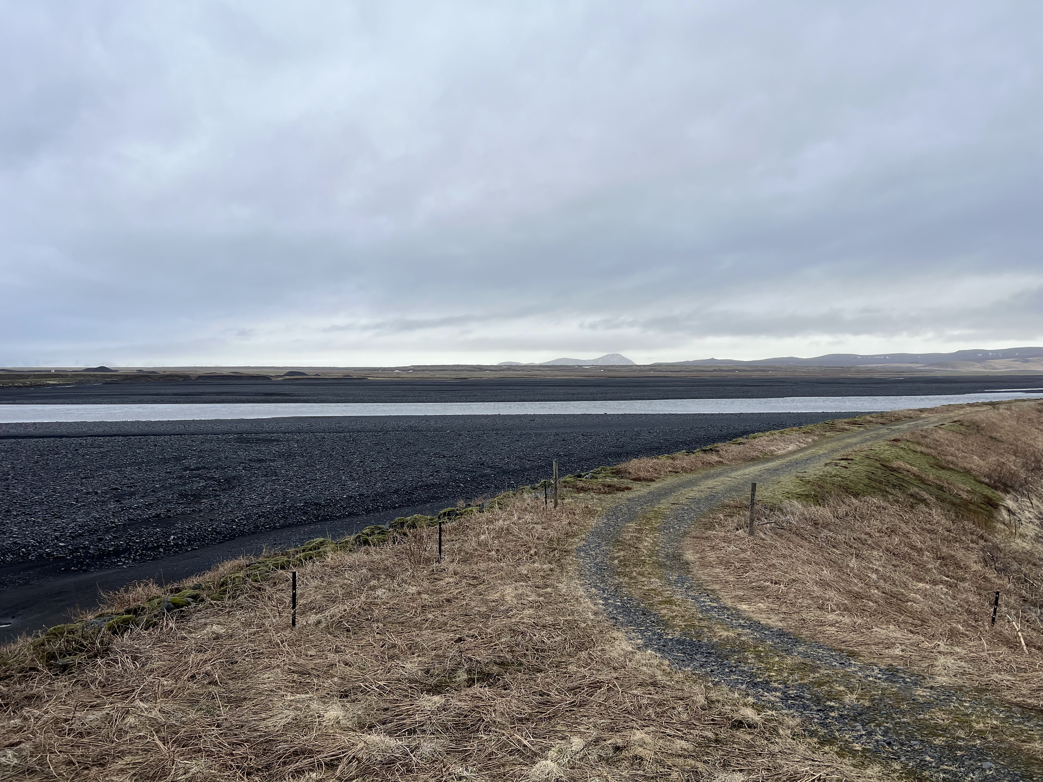
We headed east on Route 1 from Vík and crossed the entire Mýrdalssandur (yesterday we only went halfway).
As the black sand of the outwash plain disappeared I noticed that the landscape started to turn very green.
We had crossed into the Eldhraun Lava Fields (Gönguleið um Eldhraun)!
This lava field is the largest lava flow in the world! It is from the eruption of the Laki volcano which happened in 1783. The lava field covers 218 square miles and is 39 feet deep! The lava and poisonous gas from the eruption destroyed farms and killed livestock and people. About 25% of Iceland’s human population, 80% of sheep, 50% of cattle, and 50% of horses were killed because of this eruption. The Laki eruption was one of the most violent in recorded history. It reduced the global temperature by 4.5 C and caused famine in Iceland and in the continental Europe. Many historians think that this family is one of the causes of the French Revolution. The lava field is now covered with bright green moss that is very fragile and takes 100 years to grow. This place looks otherworldly and I’m not the only one who thinks so. During the 1960s NASA astronauts used Eldhraun lava field to train for the Apollo 11 mission and many Si-Fi movies and TV shows were filmed in this area.


The moss is very fragile, so we stopped at one of the designated look out areas to get our pictures. The whole area is beautiful!
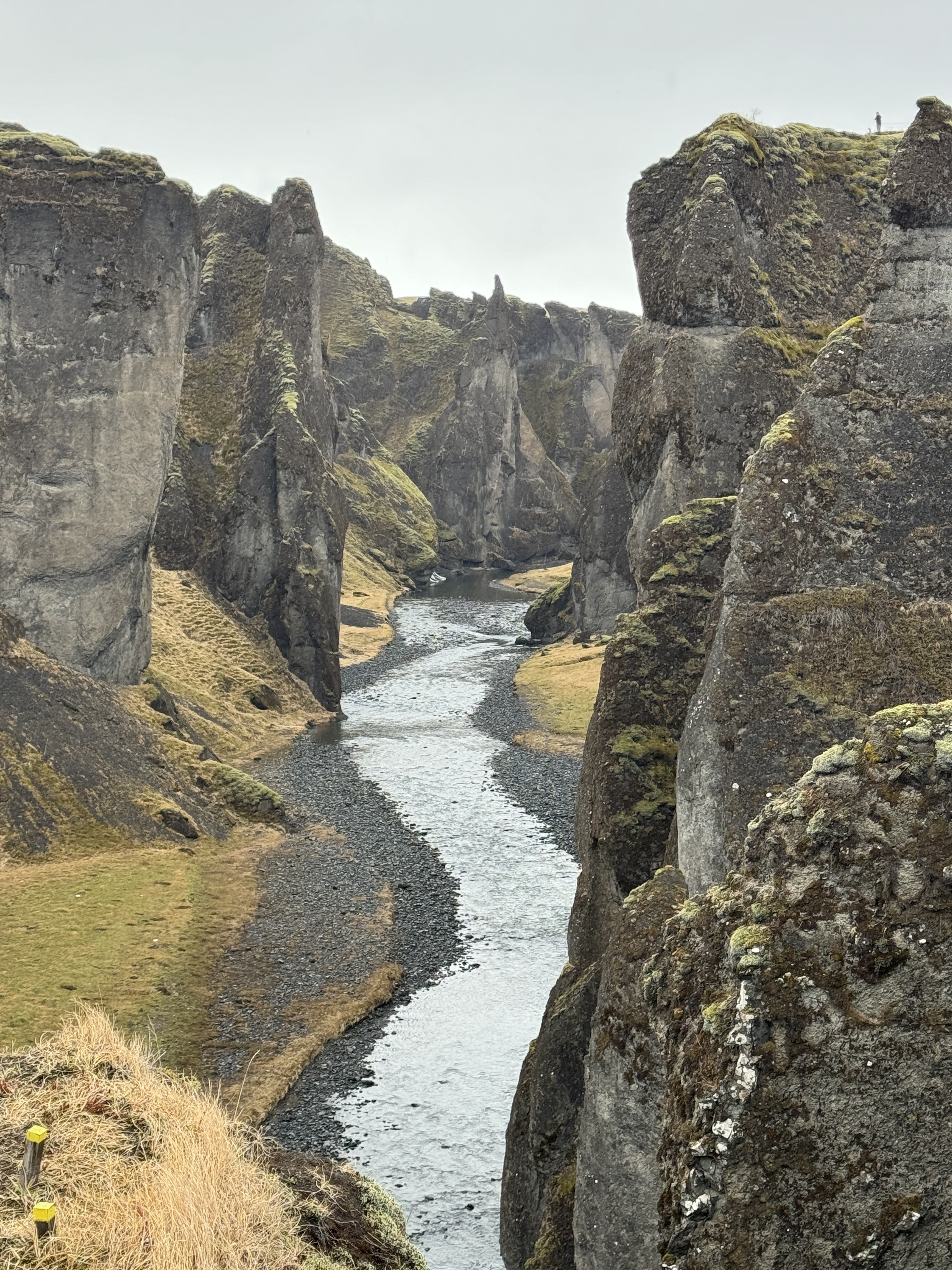
Our next stop was Fjaðrárgljúfur. The ravine was created by the runoff from a glacial lake about 10,000 years ago. A few years ago Justin Bieber shot a music video here and out on the Eldhraun Lava Fields. After that video came out fans flocked to this ravine to take pictures. Two people went out onto the cliffs and fell. One was tragically killed. This area was closed off for two years after that so the authorities could put up rope and make designated trails.
We hiked up along the ridge and got our pictures before walking over to a bridge to get a view up the canyon. I love the contrast between the green moss and the black stone. It was raining lightly and a tad foggy while we were there, but it was in the low 40s and the wind was quiet.
We left Fjaðrárgljúfur and continued east long Route 1.
[Visitor center in Kirkjubæjarklaustur - I love the turf roofs]
As we headed east the fog began to lift and we could see the mountains! The grass was starting to turn green and the whole area was beautiful!
We stopped at a look out point to get some pictures of the famous Lómagnúpur. The vertical cliffs are 671 meters tall and are the highest vertical cliffs in Iceland.
As we passed Lómagnúpur we found ourselves driving on another large sandur. And you know what that means!
GLACIER!
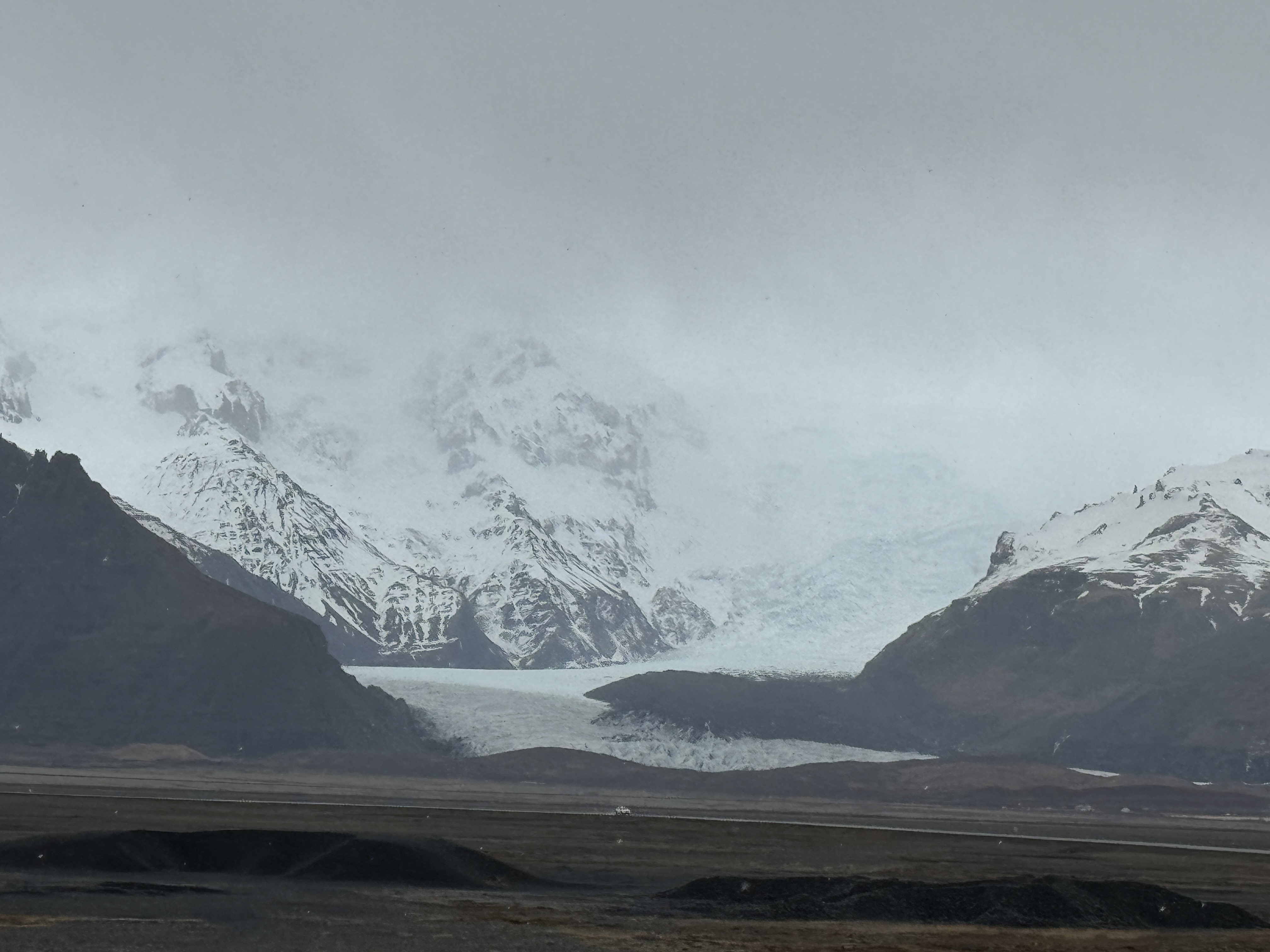
We made it to the Vatnajökull National Park and this is the gigantic Vatnajökull!
Vatnajökull is the largest and most voluminous glacier in Iceland and the second largest glacier in Europe. Under the icecap are numerous volcanos and other large peaks. The highest peak in Iceland, Hvannadalshnjúkur, stands at 6921 ft and is visible from Route 1.
Here's a map of Iceland and it's major glaciers. Langjökull is the one we went snowmobiling on and Vatnajökull is the one we are exploring now:
The Vatnajökull has 30 outlet glaciers (aka tongues). Outlet glaciers are channels of ice that flow out of an ice sheet, ice field or an ice cap, but are constrained on the sides by the topography of the mountain range. We are going to see a few of them today!
[Skaftafellsjökull - an outlet glacier of Vatnajökull]

We drove to one of the National Park Visitor centers and from there we started the hike to the Skaftafellsjökull.
We hiked to the terminus of the glacier where pieces of it were calving into a shallow lake. These pieces will melt and then flow out on the sandur to the ocean.
It was cloudy and sprinkling, but the wind had completely died down for our hike. The temperature was in the low 40s, so I had to take my beanie and outer layers off!
After the hike we continued our drive east along Route 1 to the Háalda Natural Monument.
The fog was starting to move in again, but we were still able to get a few pictures before we continued our journey.
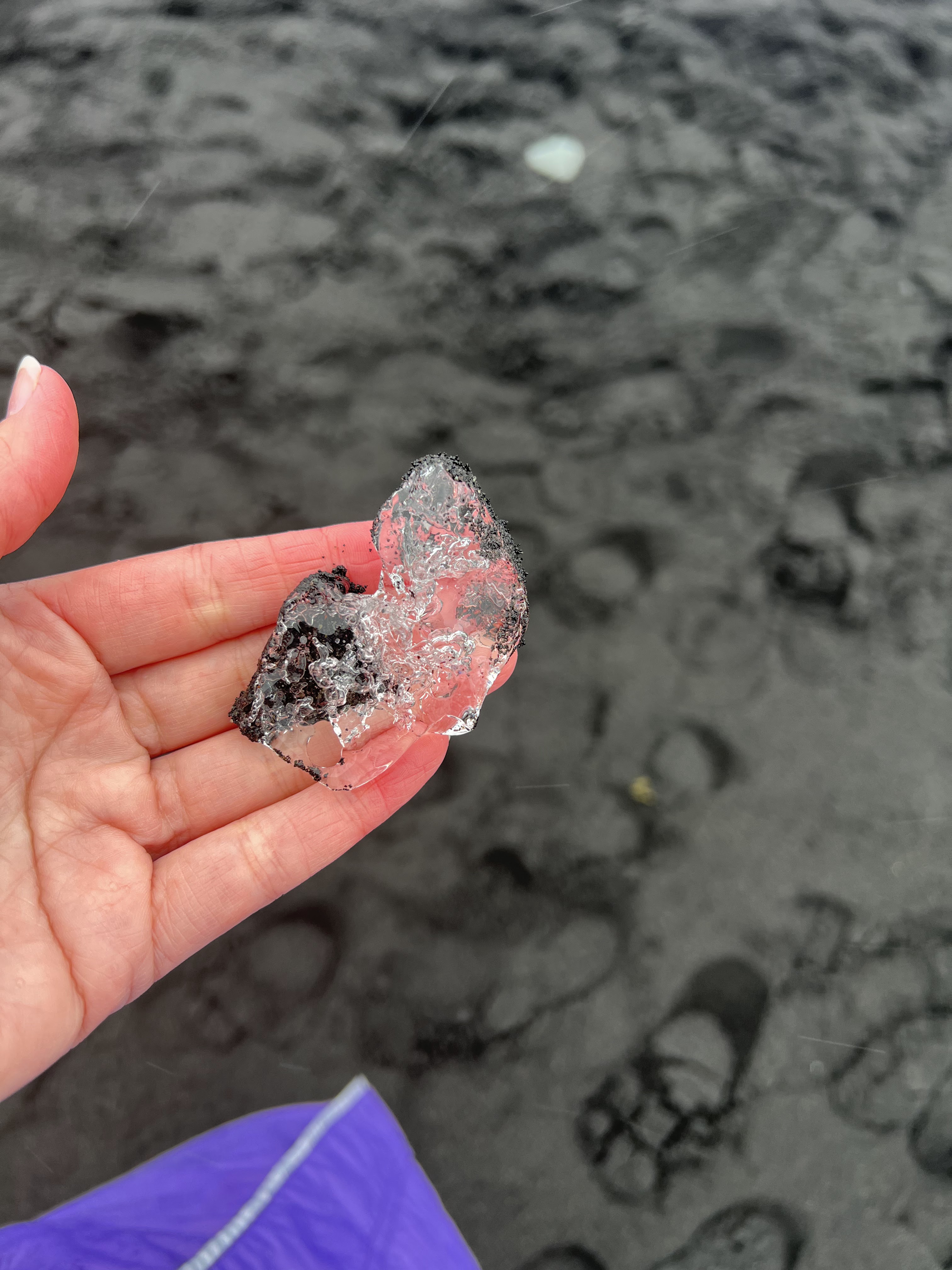
Our next stop was as far east as we could go: Diamond Beach!
This beach is covered with pieces of the Breiðamerkurjökull which is another one of the outlet glaciers from Vatnajökull. The ice calves from Breiðamerkurjökull, floats through the Jökulsárlón (glacial lake), and out to the ocean. Some pieces of ice get stuck on the beach and that's where the name "diamond beach" comes from.
Unfortunately it started raining right as we showed up, but that wasn't going to stop us!
On the other side of the bridge is Jökulsárlón, the glacial lake, which is where we are heading next.
[Huge chunks of the blue glacier sitting on the beach]
We then crossed the bridge and stood on the banks of Jökulsárlón. Unfortunately the Breiðamerkurjökull has receded a lot over the last few years. It's about 5 miles away, so we couldn't see it.

The quiet lake was FILLED with icebergs that were all making their way to the ocean. As I was looking out over the ice this black blog caught my eye. It's a seal! These grey seals come in from the sea and feast on the fish that are in the fresh water lake.
[More seals]
[Rain in our face! Also, don't bring umbrellas to Iceland, they are completely useless here!]
After exploring the peaceful lake we started the long drive back to our cottage in Selfoss. If we drove straight through it would take about 4 hours to get home. But Joyce didn't want us sitting in the car that long, so she broke up the drive with a few more stops!
We headed west on Route 1 for just a few minutes before stopping at the Fjallsjökull. This outlet glacier is massive and it has a huge lake (Fjallsárlón) where you can go on boat rides.
[Can you see the tiny boat on the lake?]
The people out on the lake looked like they were having a good time! What a fun way to see the glacier!
We then drove back to the National Park Visitor center and from there we went on a hike to the Svartifoss. During this hike you walk by three other waterfalls before you reach the famous Svartifoss.
The first 30 minutes were a little steep, but the last 10 minutes is when things got muddy and slippery!
But it was worth it!
We hiked back down to the Visitor Center where we met Joyce. We drove to Vík where we had dinner and then continued all the way back to our cute cottage in Selfoss.
I am so glad that we were able to go to the South Coast and that the weather (for the most part) cooperated with us! I just love the sandur's and the beautiful glaciers. The contrast is extreme and it makes it look like your photos were taken in black and white. I also love how he landscape was changing and turning green. I bet they are going to have a gorgeous summer!


No comments:
Post a Comment